Simam AI Lab Our applied AI research division is now open. Visit the lab
Simam Spatial Intelligence: for business

Everyone who needs to see it, without the visit.

We film your site, development or venue and rebuild it so anybody can walk it from a link on their phone: a client, a board, a buyer, a contractor, an inspector. No app, no account and no diary to coordinate. Most of what people use it for is the trip they no longer have to arrange.

Every capture is quoted for the place it is of · prices exclude VAT

Already have footage? We can work from that →

No app required · Mobile & desktop · Send a link or embed it in your own site

A development, floor by floor

  • Points of interest
  • Unit and floor detail
  • Guided tour

A drone clip in. A sales tool out.

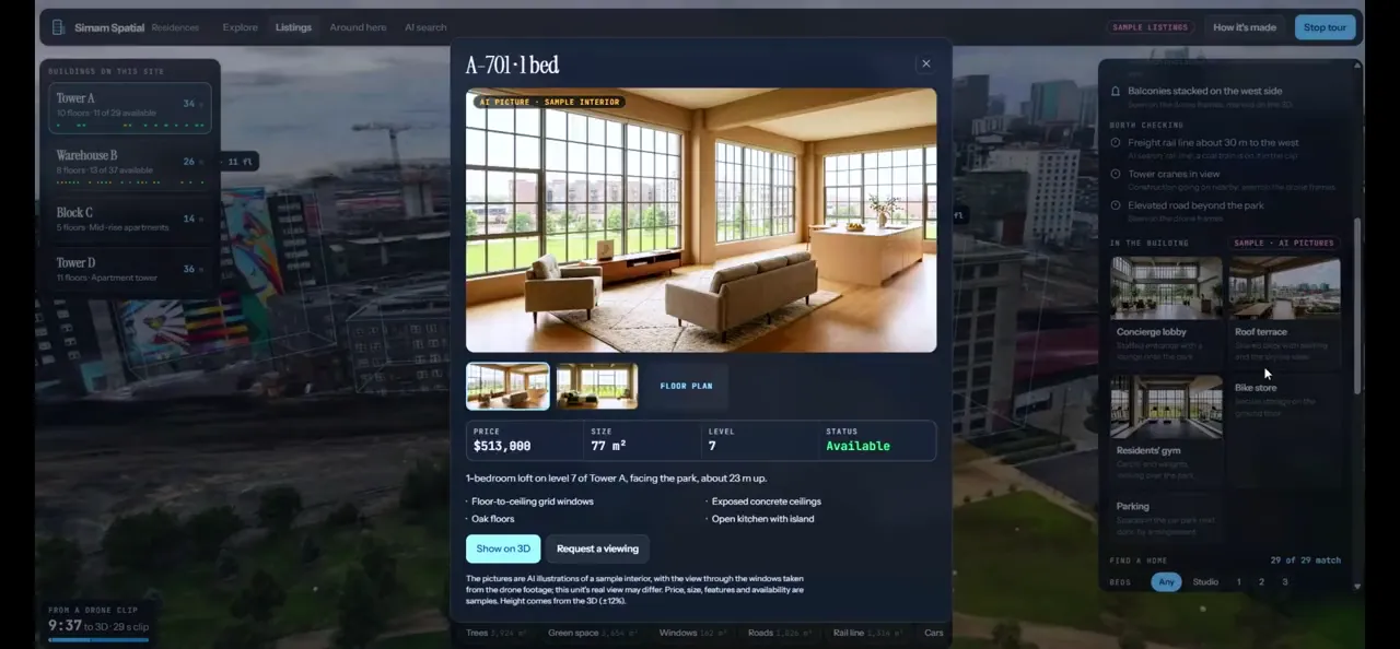
The one people ask for most. A 29-second flight over a development becomes something a buyer opens on their own phone and moves around: every block, every floor, every apartment, and what is left to sell on each one.

  • Click a block, then a floor, then an apartment
  • Availability, price, size, floor plan and outlook on each one
  • Amenities and the places nearby, with walking times
  • AI pictures of how an interior could look, labelled as illustrations
  • Enquire or request a viewing from inside the 3D, with the apartment already attached
  • Nothing to install: it opens from a link, on a phone or a desktop
  • 29sof drone footage in
  • 4buildings, 34 floors
  • 0apps to install
Request a walkthrough → Request a proposal →

It is our own build, made to show what the software does. The listings, prices and availability in it are samples and say so on screen, and the interior pictures are labelled as AI.

What a finished one looks like.

Six we have built, running in a browser. Each started as footage of a real place and ended as something a person can open, move around and read. Watch these before you look at the prices.

Request a walkthrough ↗
Bare ground, and the plan on it Day one of a site in 3D, then a sample masterplan drawn onto the real ground: plots, roads, lighting and what runs under the streets. The plan is an AI illustration and is labelled as one on screen.
Request a walkthrough ↗
A building you can pick apart A city block reconstructed, then a building, then a floor, then one unit with its own card. The same scene answers a question at every level.
Request a walkthrough ↗
A street that sells itself Six homes along a canal, each with a card, a walking route between them, and a view of the same scene at sunset. Listings and prices in it are samples.
Request a walkthrough ↗
An estate, down to the berth A private shoreline filmed from the air, then rebuilt so every house, villa and mooring carries its own card. It is a concept development of ours, and the first thing it says on screen is that every home, yacht and price in it is imagined.
Request a walkthrough ↗
A district, and the one block you came for A city district rebuilt from drone footage, each building measured off the 3D and read for its facade and its condition, with a sample register of what is for sale or to rent. The readings are a guide to look at, not a survey or an inspection.
Request a walkthrough ↗
Seven towers, every home on the face Four drone clips of a sea front became one scene. Pick a tower, then a floor, then a home, and you are standing at its window. The 1,336 homes, their prices and their statuses are generated samples rather than a real agency’s stock.

These are our own builds, made to show what the software layer does. Plans, listings, prices and the places named in them are samples, labelled as such on screen, and are not a real development or a real agency's stock.

It is not one thing, and it is not a 3D scan.

The scene is the means. What people buy is the answer to a question they already have, and that question is different for a site manager, an agent, a farm and a council. Eight of ours, and what each one is actually for.

Housing developments and societies

For a sales office, a development authority, and a buyer who cannot visit

What hurts. Buyers are asked to pay instalments on a plot they have never stood on, and the truth about who owns what lives in a spreadsheet nobody outside the office can see.

What the capture does. One flight becomes a record of the whole scheme: every plot found and marked, every block read for how far it has got, and your own register laid on top of it. Fly it again and you have the same place at two dates, which is what an allotment dispute or a progress report needs.

Construction companies

For site managers, main contractors and the insurer who wants proof

What hurts. Arguments about who did what and when. Snag lists that run to pages. Damage and theft on site, and no record of what was there the week before.

What the capture does. A dated record of the site on a schedule: before each handover, after any incident, stage by stage from groundworks to fit-out. Hazards are marked where they were seen. Compare any two dates side by side.

Infrastructure and asset owners

For anyone responsible for something large that has to stay safe

What hurts. A condition survey starts ageing the day it is written, and getting a person back to the thing often means access, traffic management and a window you do not control.

What the capture does. The asset as it actually is, with a register on it: findings scored by likelihood and severity, condition read from the air, and what is due at the next inspection. A person checks every reading before it reaches you, and none of it replaces an engineer.

Farms and estates

For a farm manager, and the lender, insurer or agronomist they have to convince

What hurts. You know what is on the holding. Showing it to somebody else means a drive round, a folder of photographs, and taking your word for the rest.

What the capture does. One flight, and everything it found pinned where it actually is: trees, barns, livestock, solar, tanks and tracks, each with how confident the reading is and the frame of footage it came from. Land use and vigour come as maps with measured areas.

Estate and letting agents

For branches losing time to viewings that were never going to convert

What hurts. Fourteen viewings to sell a home, and every empty week between tenancies is rent nobody is receiving. People who live elsewhere cannot look before they travel, so they do not.

What the capture does. A 3D of the property with a link for your listing, your own site and a message, so people look before they visit. The same capture is a dated record of condition at move-in and move-out.

Developers selling before completion

For anyone asking people to commit to a building that is not finished

What hurts. Renders look like everyone else's, buyers abroad cannot visit, and when people doubt that progress is real they slow down or stop paying.

What the capture does. Your real site in 3D with the proposed buildings placed where they will go, measured against what is already standing, and scenarios you can switch between. Then regular progress captures with a plain update.

Planning teams and councils

For officers who get objections late, from people who never saw the scheme

What hurts. Written responses to a local plan come from a fraction of a per cent of the population, and a third of people say they did not know how to take part. Objections then arrive at the end, about the wrong things.

What the capture does. Residents walk the real place with the scheme placed on it, before anything is built, from a link or a code on a notice. They take part on a phone, in their own time, having actually seen it.

High street, hospitality and venues

For places people choose before they ever walk in

What hurts. A photograph of a shopfront does not show the room, the light, or whether there is space for a pushchair. People decide from a phone and you never know which ones you lost.

What the capture does. The place itself in 3D, with what you sell on it: the menu, the counter, the terrace, and ordering if you want it. One link, and it opens anywhere with nothing to install.

Every scene here is our own build. Plans, listings, registers and the figures inside them are samples and say so on screen. Measurements taken off a capture carry about ten to twenty per cent: where a figure matters legally or commercially the surveyed number rules, and none of this is a structural or a safety assessment.

Open one and walk around it.

These are running software, not pictures of it. Pick one and it opens here, in this page, on whatever you are reading this on. Nothing downloads until you ask it to, because each scene is a large file and we would rather not spend your data without being invited.

Four buildings from one short flight. Open a block, then a floor, then a flat, and see what is left to sell on each one.

Every one of these is our own build, made to show what the software does. The plans, listings, prices and registers inside them are samples and say so on screen. If a scene will not open on your machine, the link above it opens the same thing in its own tab.

And what does it do for you?

That depends on who you are. Pick the one that sounds like you and you get the thing it actually costs you today, what we do about it, and the published figures behind it, with the limits stated.

Not sure which you are? Read them all on one page, or tell us about the site and we will say which is the smallest step worth taking.

Where to start.

Each list is what a project at that level usually includes, not a fixed menu: most of what people ask for is shaped around their own site once we have seen it. Every job is quoted after we have looked at your location, and we tell you what it will cost before anything is booked.

“We have a lot of sites, or a lot of users.”

Then it is not priced per site at the single-site figure, because that arithmetic does not work for anybody. Tell us how many sites, how often each needs doing and roughly how many people will open them, and we price the estate rather than the site. The number of sites changes the conversation more than anything else on this page, and it is the conversation we would much rather have than lose.

“Can we pay monthly instead?”

Yes. A smaller figure to get it built and live, then a monthly that keeps it running and recaptures the place as often as it needs. For a site that is still moving this is usually the better arrangement anyway, and it is the one most people end up on.

“Can we start with something smaller?”

Yes, and we would rather you did. One building, one block, one phase, one room. Small enough to see quickly and real enough to judge, before anybody commits to the whole thing.

“Can we see it properly for nothing first?”

Yes, and you do not have to ask. Every demo linked from this page is the real thing, free to open, with its own write-up saying what it gets wrong as well as right. Send us footage of your own place and we will tell you whether it will rebuild, also for nothing, before any question of paying comes up.

“Can we just buy the software?”

Not at the moment. We used to sell the viewers as source code and we have stopped while we work out what that should look like, so today the honest answer is that we build it and you keep the files. If running it yourself is the whole point for you, say so when you get in touch and we will tell you where that stands rather than selling you the wrong thing.

“Can we keep it on our own systems?”

The finished scene and its files are yours and they run anywhere, so hosting it yourself is a matter of where you put the folder. Anything further inside your own network is real engineering rather than a setting, so ask early and it is scoped with the rest.

What things start at

We come and film it

We travel to you, film the place and build the scene. That is the scene itself, on a link you can send. Building it into an experience with your branding, your information and your pages on top is the Starter above. Within about 20 miles of Wakefield; further afield we price the travel and say so before you book.

Quoted
Hosting after that

Keeps the scene live and lets us make small changes to it. Priced on how many scenes you have and how much traffic they take.

Quoted
Anything larger

Several sites, a sales or booking system, dated records over time. It starts with a paid discovery, scoped with you, and the discovery is credited in full against the build.

Quoted

Those are the shapes most projects take, not a menu with prices on it. Every site is different, so your own job is quoted once we have looked at it, and you get that figure with the scope beside it before anything is agreed. We look at the site at no charge and tell you straight if it will not work. Drone flights, where one is needed, are quoted separately. Already filmed it yourself? Tell us what you have on this page and we will say what it can support before quoting.

If the thing you want is not on this page, ask for it anyway. The answer is usually yes, and where it is genuinely no you will hear that straight away rather than after a fortnight of emails. The four packages below are what most projects look like, not the only shapes we will sell.

Spatial StarterA single location
Quotedafter we understand your needs

Perfect for a single space.

  • Professional on-site capture of one location
  • 3D reconstruction of the site, cleaned and optimised
  • Our experience, branded as yours: your name, logo, colours and words. A different kind of page, or new data layers on top, is quoted separately rather than absorbed into this
  • Three points of interest: listings, local amenities, wayfinding where the site allows
  • A building and floor viewer, with details and pricing on each unit. Request a walkthrough
7 more ↓Show less ↑
  • Alternative AI-generated views of the same place, labelled as illustrations
  • One cinematic camera path
  • Mobile and desktop, opened from a link with nothing to install
  • Three months hosting: on your own domain if you have one, or we set one up
  • The scene files, yours to keep, whoever you work with later
  • We look at the site before anything is booked, at no charge, and give you a plain answer if it will not work
  • One round of changes once you have seen it
Request a proposal →
Premium ExperienceLarger organisations
Quotedafter we understand your needs

For larger spaces. We agree which of these matter to you.

  • Everything in the Interactive
  • Large or multi-building sites, where one session will not cover the ground
  • Points of interest without a cap, grouped into layers a visitor can switch on and off
  • An AI guide that answers visitors’ questions from the information you give us, in plain language
  • Headset viewing where the scene allows it, so the same link can open immersively as well as in a browser
10 more ↓Show less ↑
  • Private links and access control, so you decide who can open which scene
  • Measurements where validated survey or CAD data supports them, and said plainly where it does not
  • Visitor analytics: what people opened, how far they got and where they stopped
  • An embed that drops the scene into a page on your own website
  • AI before-and-after views of a space as it could be changed, labelled as illustrations. Request a walkthrough
  • Saved viewpoints your team can jump straight to, and send to someone else
  • A guided presentation mode, so your team can drive the scene themselves on a call with the route already set up
  • Labels in more than one language, if your visitors are not all English speakers
  • Then and now: an earlier capture of the same site held beside the current one, with your own photographs alongside it
  • Twenty-four months hosting, and a round of content updates inside the first year
Request a quote →
Digital Twin ApplicationEnterprise & operations
Quotedafter a paid discovery

Measurement, registers and condition. Scoped on site, then fixed-quoted.

  • Starts with a paid discovery visit, deducted in full if you go ahead
  • A full capture plan, with every location identified
  • A fixed quote for the build before anything is committed, covering the parts of this list your operation actually needs
  • Your own browser application, not a scene with your logo on it
  • A dashboard beside the 3D (totals, a searchable register and plain-language search, for the people in your organisation who will never open a 3D scene) request a walkthrough
12 more ↓Show less ↑
  • Built to your brief, under the fixed quote
  • Your survey, CAD or GIS data brought in and lined up with the capture, so the figures that decide boundaries and quantities come from your surveyed records, with the 3D showing where they sit
  • Live operational data on the 3D itself: status, sensors, occupancy, progress
  • Sign-in, roles and permissions, so different teams see different things
  • A content editor your own team can use, so changes do not all come back through us
  • Recapture on a schedule, so the site shows change over time rather than the day it was flown
  • Integration with the systems you already run, agreed before the build rather than discovered during it
  • Exports your other systems can read, so the data is not locked inside a viewer
  • A staging copy, so a change is tested before anyone in the business sees it
  • An audit trail of who changed what and when
  • Onboarding for your team, so it is still used six months after we leave
  • Support and updates, scoped and priced in the same quote
Ask about Discovery →

Have it built once, and own it

You pay for the capture and the build, and what you end up with is yours: the finished thing on your own domain, and the scene files to keep. Hosting is included for a while and then it is yours to put wherever you like. This is the right shape when the place is finished and the record does not need to change.

Or a smaller setup, then a monthly

A lower figure to get it built and live, and a monthly fee after that. For the monthly we keep it running and hosted, make the changes you ask for, and capture the place again at whatever interval suits it. This is the right shape when the site is still moving, when somebody needs to see what changed, or when a smaller number up front is simply easier to approve.

Which one costs less depends entirely on which you need, so we quote both rather than lead with one. Tell us about the place and what it has to do, and you get the figures for both routes in the same reply. There is nothing to pay to find out, and if your site is a poor candidate we will say so at that point rather than after you have committed to anything.

Want something that is not on any of these lists? Tell us what it needs to do. A great deal of what we have built started as one line from a customer about their own site, their own property or their own client, and we will come back with a price for building it rather than a reason it does not fit a package.

What you keep is the finished experience and your own scene files, on your domain, hosted wherever you like. What stays with us is the pipeline that produces it: the hardware, the processing time and the work of keeping it running between jobs. That is what this price pays for, and it is why this page is priced for people who would rather not run their own GPUs. The Starter covers one location end to end: the visit, the reconstruction, the cleanup and a branded experience your customers can open from a link. Most organisations start at the Interactive tier, because that is where the capture stops being a model and starts being something people actually use. All prices exclude VAT, which is added at the UK standard rate at checkout. Final pricing depends on access, scale, travel, capture conditions and deliverables. On its own, a capture measures to within about 10–20%; for boundaries and quantities the surveyed figures rule, and a 3D scene is not a substitute for a licensed surveyor. Bespoke software is also priced on our pricing page.
Capture is the easy part.

A reconstruction on its own is a model. What makes it worth having is the software layer we put on top, and these are ours: built here, measured honestly, and open in a browser right now.

Society sector

  • 4 blocks measured
  • 142 units listed
  • Register read against the 3D

A whole sector from 23 seconds of stock drone footage. Each block is measured from the 3D (height, floors, footprint, floor plate) and a sample register sits on top of it: which flats and shops are sold, booked, on instalments or still free, floor by floor. The figures are sample data; the measurements are read from the model.

Request a walkthrough →

Society Map

  • 52 buildings found
  • Stage read 83%
  • Records checked against the ground

One 20-second drone clip over a housing society, rebuilt in 3D with every plot found and read for how far it has got. The society’s own register sits on top: who owns each plot, what they have paid, whether possession was given, and every place the records disagree with what the drone saw. Each owner opens a private passport for their own plot, from anywhere in the world.

Request a walkthrough →
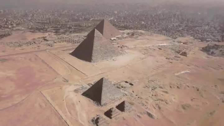
The Giza plateau rebuilt in 3D from a single drone flight, all three pyramids standing above Cairo

Giza, rebuilt

  • One 65-second flight
  • Menkaure within 4%
  • Then and now, same camera

The plateau rebuilt from one drone clip. Press a year and each pyramid rises to the height it had reached, Khufu first, then Khafre, then Menkaure, with a picture of the same view in that year beside it to drag between.

Request a walkthrough →

Site progress

  • 113 plots found
  • Stage read 81%
  • Walkable ground map

One short drone pass over a housing site, rebuilt in 3D with every plot pinned where it stands and coloured by how far it has got: foundations, slab, structure going up, roofed. Machines and materials are counted, and the walk from the site cabin to every unfinished plot is mapped.

Request a walkthrough →

4D playback

  • Video to 4D
  • Capture report
  • Spacetime trails

A flat video rebuilt in space and in time. Scrub the clip, freeze a moment and walk around it, or watch every moving point build up in the order it was captured.

Request a walkthrough →
People and machines lifted out of an ordinary video into a scene you can walk around

Memory projector

  • Metres from one video
  • Segmented cut-outs
  • Scored AI narration

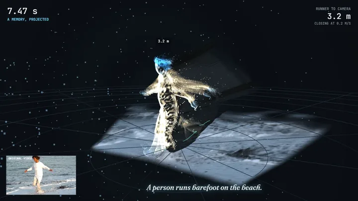
Ordinary video lifted into a three-dimensional memory you can walk around, with people and machines measured in metres from the footage itself. Built for incidents, near misses and anything worth reviewing from another angle.

Request a walkthrough →
Moments of a video stacked into a block of time along the path the camera flew

Time sculptor

  • AI depth per moment
  • Camera path from video
  • Find and track

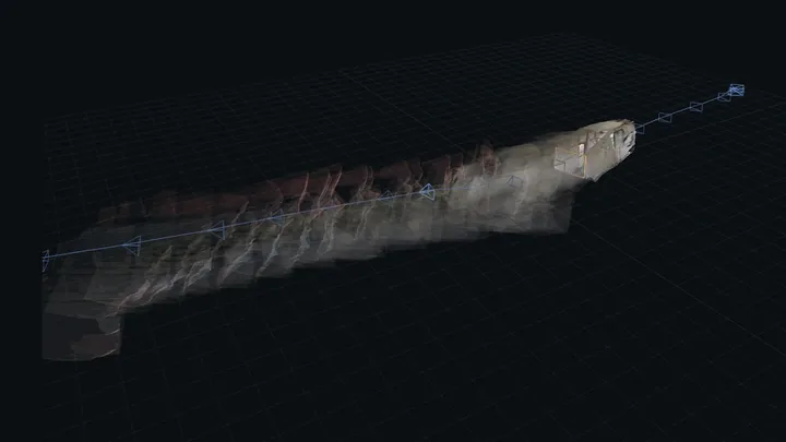
Every moment of a clip becomes a slice, stacked into a block of time or strung along the path the camera actually flew. Type what you are looking for and its route is drawn through time.

Request a walkthrough →
A 360 warehouse scene rendered as stereo 3D for a headset

360° into VR 3D

  • Depth in every direction
  • Omni-directional stereo
  • WebXR

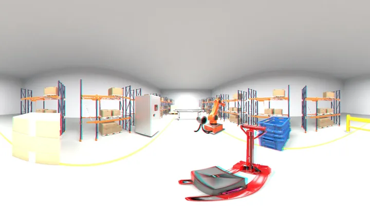
A flat 360 clip turned into proper stereo for a headset, with distance estimated in every direction and both eyes built across the whole sphere. Opens on a Quest, or in red and cyan on a laptop.

Request a walkthrough →

These are live demos rather than showreels, and each write-up says plainly what it gets wrong as well as right. Where one of them fits your project it is built into your package, not sold as an extra. See the whole lab →

We have already shipped this for a client: a drone-captured construction site routed on in the browser, and a site operations map for a live megaproject, both delivered for a high-profile US client on a programme for a high-profile Middle East client. The programme was theirs to deliver and we were not a direct client of the end client. The site itself stays confidential, so the pages describe the build rather than the site. The splat wayfinding build → The site operations map →

What you walk away with.

One visit, several possible outcomes. Most projects use more than one of these.

A link, or an embed in your site

In every package

A hosted experience at its own address, to send by email or message or put behind a QR code at the place itself. It can also sit inside a page on your existing site, in your own layout. Nothing to install either way.

360° video and social content

Optional extra

Immersive 360 footage, cinematic edits and short-form clips, filmed on the same visit rather than needing a second one.

A working application

Digital twin projects

For when the place has to do more than be explored: live data, dashboards, logins, integrations and workflows.

More than a 3D scan.

Once a place becomes software, we can build on top of it.

Interactive hotspots

Attach stories, products, assets, images and information.

Guided journeys

Cinematic camera paths and authored tours.

Then & now

Connect archival imagery and historical reconstruction.

360° & immersive media

Add 360 video and immersive sequences.

AI guide

Conversational answers grounded in approved project content.

GIS & maps

Connect captures to real geographic context.

BIM & asset data

Link structured building and engineering information.

Operational digital twins

Extend into live data, dashboards, APIs and workflows.

Enhance your capture.

Optional extras, added to any package.

360° immersive video

Quoted per finished minute

Immersive 360 footage with a professional edit.

Stereoscopic / depth

Quoted per finished minute

Depth-enhanced or stereo output where it suits the material.

Cinematic social content

Quoted with the visit

Short-form cinematic content captured during the visit.

Additional capture zone

Quoted per zone

Another room, area or nearby capture.

Historical reconstruction

Quoted per reconstruction

Interpretive visualisation from supplied or researched reference material.

Custom development

Quoted per day

Bespoke features, integrations and engineering.

Your drawings brought in as a layer

Quoted per drawing set

Your DWG, DXF, IFC or PDF drawings cleaned up, repaired where they need it, cut down to what a browser can hold and lined up with the capture, so they open as a layer somebody can switch on. Where the drawing and the capture disagree, the drawing is the figure that counts.

Heavy models made to open

Quoted per model

A design or coordination model that was never built to open on a phone, reduced and rebuilt until it loads in a browser, keeping the geometry people are actually looking at.

Footage repaired and stitched

Quoted per project

Clips from different days, cameras or people joined into one scene, the gaps found and listed so they can be filmed again, and faces, signage and documents blurred before anything is published.

Accounts and role-based access

Quoted with your package

Separate logins for your staff, your owners and your contractors, each seeing only what belongs to them.

User and owner management

Quoted with your package

Invite, suspend and transfer accounts, with a private view of their own plot or unit for people who may never visit in person.

Your records on the map

Quoted with your package

Ownership, payments, possession and documents held against each plot or unit, beside the capture instead of in a spreadsheet.

Plan checked against the ground

Quoted with your package

Your approved layout compared with what the capture actually found, with every disagreement listed for someone to review.

Site and works management

Quoted with your package

Phases, works and conditions tracked over time, with later captures added as the site changes.

Hosting and updates

Quoted with your package

Beyond the hosting included in your package: continued uptime, backups and changes to the experience as the place itself changes.

Why Simam Digital.

We are a product engineering studio that captures places, not a scanning service that also does websites. What you buy here is Simam Spatial Intelligence: your place captured, and then made to answer questions about itself. What is where, how much of it there is, what has changed, what is left to sell. If what you want is simply the scene itself, for a café, a shop or a single room, that is Simam Spatial Capture and it has its own page and its own prices.

Professional spatial capture

Purposeful capture, planned around the experience, rather than casual phone scanning.

Custom reconstruction pipeline

Captures are processed, cleaned and optimised for the experience they are going into.

Interactive web delivery

Experiences open directly in modern browsers, on the devices your audience already has.

Software engineering included

Projects can grow into custom applications, AI, GIS, BIM and operational systems.

Four steps, then a link.

From a real-world visit to a shareable interactive experience.

We captureyour siteOr you sendexisting footageWe reconstructthe placeWe buildthe experienceWe connectyour dataHosted by usnothing to installOn your owndomainEmbedded inyour siteWe captureyour siteOr you sendexisting footageWe reconstructthe placeWe buildthe experienceWe connectyour dataHosted by usnothing to installOn your owndomainEmbedded inyour site
However the footage arrives, the pipeline is the same one.
  1. 01

    Capture

    We visit the place.

    A purposeful walk of the site with 360 capture, planned around what the experience has to show.

  2. 02

    Reconstruct

    Reality becomes spatial 3D.

    Frames are aligned and trained into a Gaussian reconstruction, then cleaned and optimised to load on a phone.

  3. 03

    Author

    We turn the capture into an experience.

    Points of interest, camera paths, media, audio and navigation, authored in our own browser editor.

  4. 04

    Publish

    You send a link.

    Hosted, shareable and embeddable in your own site. No app, no install, no headset.

Already have footage? We can start at step two.

Same packages, same basis, whether we come to you or work from footage you already have

If the place has already been filmed, we do not need to travel to it. Send us what you have and we will tell you honestly whether it can be reconstructed, before anyone commits to anything. It is how most of our work outside the UK starts. The price does not change because you filmed it yourself: what you are paying for is the experience built on top, not the drive to your site.

If all you want is the reconstruction itself (one place, one scene, a page you can share and the files to keep) that is a different and much smaller job, and it has its own page with its own prices on it: 3D from your own video.

Footage works best when the camera moves steadily and covers the space from many angles, with even light and enough resolution to hold detail. Drone video, 360 footage, video walkthroughs and large photo sets can all work. We will say so plainly if yours cannot, and nothing is charged for looking.

Send us your footage →

Book a capture in 60 seconds.

Tell us about the place. We will review the location, recommend the right package and confirm availability before you pay anything. A quote comes first, and your date is booked as soon as payment clears.

Start your capture request →

Questions.

The ones we are asked first.

What is spatial capture?

We capture a real place from many viewpoints, or work from suitable footage you already have, and rebuild it as a three-dimensional scene you can move around inside, in a web browser. It looks like the place because it is made from images of the place.

Is this the same as a virtual tour?

No. A virtual tour moves you between fixed points. A spatial capture lets you move freely through the space, and because it is software we can build things on top of it: information, guided journeys, media, data and AI.

Do visitors need an app or a VR headset?

No. The experience opens from a link in a normal browser, on a phone or a laptop. Immersive headset modes can be added where they are useful.

How long does capture take?

It depends on the size and complexity of the location and on access. We confirm it after reviewing your site, before anything is booked.

How long does processing take?

Timing is confirmed with your quote, once we have seen the location and know what the experience needs to do.

What locations work best?

Good, even light; surfaces with visual detail; a space we can move through steadily; and not too much moving traffic or crowds. Send us photographs and we will tell you honestly.

Can you capture active construction sites?

Yes, subject to permission, access and site safety requirements. Progress capture over time is one of the more useful things this technology does.

We already have CAD drawings or a model. Can you use them?

Usually, yes, and this is one of the more common pieces of work on the larger projects. DWG, DXF, IFC and PDF drawings can be cleaned up, repaired, reduced to something a browser can hold and aligned to the capture, so your plan sits as a layer over the real place rather than in a file somebody has to download. A heavy design or coordination model can be rebuilt to open on a phone. Send us what you have and we will tell you what state it is in before quoting it. Where your drawing and our capture disagree about a dimension, your drawing is the figure that counts.

Is the model survey accurate?

Not by default, and we will not claim otherwise. A reconstruction is primarily visual. Where measurement matters, authoritative BIM, GIS, CAD or survey data can be integrated alongside it.

Can the experience be embedded on our website?

Yes. It is a web page, so it can sit inside your own site as well as living at its own link.

Can we add information later?

Yes. Points of interest, media, navigation and software features can all be extended after launch.

How does payment work?

Prices on this page exclude VAT, which is added at the UK standard rate. Nothing is charged until you have seen a quote and accepted it. Once you are happy with it we send the invoice, and the capture or the reconstruction is scheduled as soon as it clears. We invoice from Simam Digital Ltd and you can pay by card or bank transfer.

Why do you take payment before the work starts?

You are never asked for anything before you have a quote you are happy with. We look at the site or the footage first, tell you what it can realistically become, and if it is not a good candidate we say so at no cost. Once you have accepted the quote, payment comes first because everything we make is digital and hosted, and a capture visit is a day of our time and the travel to reach you, held for you alone. Paying up front is what makes the date real for both of us.

We already have video of the place. Can you use it?

Often, yes. If the footage moves steadily through the space, covers it from enough angles and holds enough detail, we can often reconstruct from it without visiting at all. The packages and the basis are the same either way, because what you are buying is the experience we build, not the journey to your site. Send it over and we will tell you what it can and cannot become before you commit to anything.

What kind of footage do you need?

Drone video, 360 footage, a steady video walkthrough or a large set of overlapping photographs can all work. What matters is coverage, steady movement, even light and resolution. A short clip of one wall cannot become a space you walk through, and we will say so rather than take the work.

Can you travel?

Yes. Travel is quoted as part of the project, and depends on where the location is.

Request a proposal →