What state is it in, and when did we last look?
A register that can be re-flown and compared, rather than a report that ages from the day it is signed.
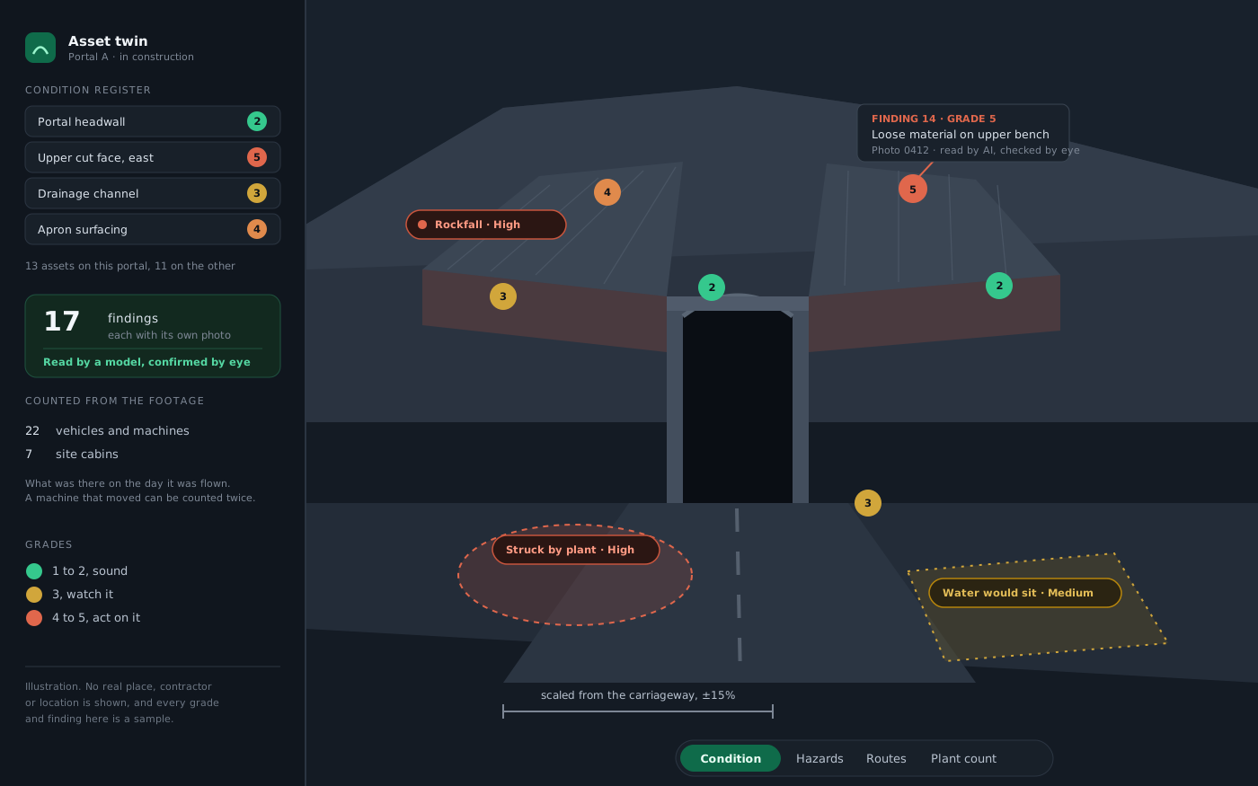
We built this one ourselves, to find out what a dated record of an asset could actually carry if the only input was footage. Two road tunnel portals, one still being built and one already in service: a graded condition register, findings tied to the photograph each one came from, counts of what was on site that day, and hazard zones. Every tolerance on this page is stated rather than implied.
Condition records go stale the moment they are filed. They live in a report somebody wrote after a visit, and the next person to need them is reading about a site that has moved on. We wanted to know whether a routine flight could produce something better: a record you can walk around, where every judgement is attached to the picture it was made from, and where doing it again next month is cheap enough to be worth doing.
A register that can be re-flown and compared, rather than a report that ages from the day it is signed.
Every grade and finding on this build points at the frame it came from, so a reading can be argued with rather than taken on trust.
Plant, cabins and vehicles counted from the footage, which is a different question from what the schedule says should have been there.
One portal under construction, one in service, each from a single drone pass. The twin holds a condition register with every asset graded and pinned in place, findings carrying the photograph behind them, routes and security points, a plant count, and an export so the register can leave the browser.
A reconstruction will always agree with the pictures it was built from. The only honest test is to keep some back and see whether it still agrees.
A portion of the footage was kept out of the reconstruction entirely and then used to test it, which is the only check that catches a model confidently inventing geometry it was never shown.
Scale comes from objects in the scene whose dimensions are known, a carriageway on one portal and lane widths on the other, rather than from anything the footage asserts about itself.
What the measurements are worth, stated plainly. Nothing here was surveyed. Size comes from things visible in the footage whose real dimensions are known, so the portal under construction carries about fifteen per cent either way and the one in service, where lane widths gave a better anchor, about ten. That is enough to judge a slope, place an asset and compare one month against the next. It is not enough to settle a boundary, sign off a structure, or answer a compliance question, and where a surveyed figure exists the surveyed figure wins.
For anyone who wants the figure behind that: measured against the held-back frames, the two reconstructions scored 31.5 dB and 31.6 dB, with structural similarity of 0.92 and 0.93. The counts of plant and cabins are what the footage shows on the day it was flown, and a machine that moved during the flight can be counted twice.
A case study that lists only successes tells a buyer nothing about what happens when something slips.
Brand wording and warning stickers on the plant survived the first anonymising pass, and between them they named the country. The frames were blurred again, a vehicle was softened, and the build was restarted from the cleaned frames rather than patched.
One portal’s reconstruction failed on a graphics error after a checkpoint. It was resumed from that checkpoint rather than restarted, which is the whole reason for checkpointing.
Both were stopped and a single clean resume was run. Not every failure is interesting, and a process that cannot survive a dull one is not a process.
The blur pass is the one to read. Anonymising a scene is not a box to tick. The first pass looked clean and was not, and it was caught by going back and checking rather than by anything automatic. That is the process this page is really evidence of: assume the first pass missed something, and look again before anyone else does.
The hazard model flags where rockfall, plant movement and standing water look likely from the shape of the ground. Those ratings are estimates produced from geometry. They are a prompt for somebody qualified to go and look, and they are not a safety assessment.
The insides of the bores and the ground behind the slopes were never flown, so they are simply empty rather than wrong. North is not derivable from the footage, so there is no sun study. The asset grades shown are samples rather than a real inspection.
There is no time saving or cost saving figure on this page, and that is deliberate: none was measured. The obvious claim here would be how many site visits this replaces, and we would be inventing it. The footage is stock, not a client’s asset, and the place, the region and the contractor are not named.
This was our own build on stock footage, which means the method is proven and the register is invented. On a real asset the same pass produces a real one, and the honest first step is us looking at your footage, or telling you how to fly it, before anybody quotes.